Water Cycle Protocol Bundle - Earth as a System
Water Cycle Protocol Bundle
Water, an essential component to life on Earth, continuously circulates through one of the planet's most powerful systems: the water cycle. Water flows endlessly between the ocean, atmosphere, and land, frequently changing forms as it moves between these domains.
Furthermore, the water on Earth is a finite, fixed quantity. This means that the amount of water in, on, and above our planet doesn't increase or decrease.
Learn more about MyNASA Data and the Water Cycle protocol bundle.

Studying the Water Cycle
NASA studies the water cycle with a variety of techniques. Researchers studying the water cycle use satellites, airborne campaigns, and ground-based measurements to collect data and learn more about how water circulates through our planet's various systems. This data is used in many real world applications to answer vital questions essential to our survival on this amazing “water planet.” The contributions from GLOBE scientists, teachers, and students are important elements supporting this effort, and directly help us become better stewards for the water in our environment.
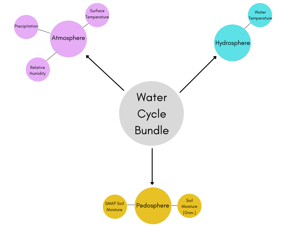
Bundle Overview
- Atmosphere
- Surface Temperature
- Surface temperature affects a local area's rate of evaporation. This rate determines how much water vapor is present in the atmosphere at any point in time.
- Precipitation
- The amount of precipitation that falls on an ecosystem influences how much water seeps into the soil and pools into reservoirs like lakes, rivers, and aquifers.
- Relative Humidity
- Relative humidity is a measure of how much water vapor is present in the air and is a strong indicator of how rapidly water is moving from Earth’s surface, to the atmosphere, and back again
- Surface Temperature
- Pedosphere (Soil)
- SMAP Soil Moisture
- By studying soil moisture with satellite-assisted data like SMAP, we can draw conclusions on how the water cycle is functioning on a larger scale. Via soil moisture measurements, we can tell if an area is experiencing unusually wet or abnormally dry climatic conditions.
- Soil Moisture (Gravimetric)
-
By taking soil moisture measurements from physical samples, we can not only verify satellite-gathered data, but we can also learn more about how moisture varies as we move further from the surface. These measurements are crucial for understanding how deeply the water penetrates the ground, how quickly water is evaporating, and how much water is likely to be gathered in natural reservoirs.
-
- SMAP Soil Moisture
- Hydrosphere
- Water Temperature
- The temperature of a water body influences its evaporation rate. This has direct consequences for the body's water level as well as the relative humidity and weather patterns for the surrounding habitat.
- Water Temperature
Precipitation is a vital component of how water moves through Earth’s water cycle, connecting the ocean, land, and atmosphere. Knowing where and how much it rains, as well as the makeup of the precipitation, allows scientists to better understand how that precipitation affects rivers, surface runoff, and groundwater. When these measurements are conducted frequently with great detail, scientists can construct models of and determine changes to the Earth’s water cycle.
Scientific models of the water cycle help describe how water:
- Evaporates from the surface of Earth
- Rises into the atmosphere
- Cools and condenses into rain or snow in clouds
- Falls to the surface as precipitation
When this water falls back to Earth on land, it collects in rivers, lakes, soil, and porous rock layers, with much of it flowing back into the oceans. Throughout this drainage process, there are many chances for the water to reevaporate back into the atmosphere where it will begin the cycle once more. This cycling of water in and out of the atmosphere significantly influences many other aspects of life on Earth and is a direct driver of our regional weather patterns.
Before taking measurements out in your local community, it's beneficial to first focus your approach by creating research questions. A few examples of these questions include:
- How does the water cycle impact the types of plants that can live in an ecosystem?
- How does the water cycle change throughout the year where I live?
- How does air, soil and surface temperature affect soil moisture?
- Is there a relationship among precipitation, relative humidity and soil moisture?
- How are the energy and water cycles related?
Case Study 1
Research title: A study of air quality and soil on bryophyte diversity in rainforests, Southern International Botanical Garden (Thung Khai), Yan Ta Khao District, Trang Province
Research team: Mr. Chawakorn Pongkuea, Mr. Parit Lungyai, Mr. Tiwakorn Jitlang
Mentors: Kwanjai Kanchanasrimek, Orapin Noonum
Scientist: Ms. Sunadda Daengyong
GLOBE School: Wichienmatu, Trang
Level: Mathayom 5
Research team: Mr. Chawakorn Pongkuea, Mr. Parit Lungyai, Mr. Tiwakorn Jitlang
Level: Mathayom 5
Advisors: Kwanjai Kanchanasrimek, Orapin Noonum
School: Wichienmatu, Trang
Scientist: Ms. Sunadda Daengyong
Summary
A study of air quality and sediment on bryophyte diversity in the rainforest. Southern International Botanical (Thung Khai), Yan Ta Khao District, Trang Province the objective of this study was to study air quality on bryophyte diversity in rainforests and to study the physical properties of soil affecting the diversity of bryophytes in the rainforest at the Southern Botanical Garden. The method of operation is to measure soil quality according to the GLOBE method by measuring temperature, pH, soil moisture, air relative humidity and surveying the diversity of bryophytes. The study air and soil quality on bryophyte diversity in the rainforest at Southern Botanical Garden (Thung Khai), Yan Ta Khao District, Trang Province, found that the factors affecting the diversity of bryophytes in the evergreen forests of the Southern Botanical Garden (Thung Khai) were temperature, pH, moisture of soil and air relative humidity for 6 types of bryophytes were found in study area. For five species of bryophytes and one species of liverworts were found, mainly on trunks, two species found on logs, branches, rocks and stumps.
Research Question
Air quality and physical characteristics of soil affect the diversity of bryophytes in the rainforest.
Research Hypothesis
Air quality and physical characteristics of sediments are different. The affects of bryophytes diversity in the rainforests of the Southern Universal Botanical Garden are different.
Protocols
- Soil temperature
- Soil Moisture
- Soil pH
- Relative Humidity
Discussion
The study of air quality and sail on bryophyte diversity in the rainforest. It was found that the factors affecting the diversity of bryophytes in the rainforests of the Southern Botanical Garden (Thung Khai) were soil of sed temperature moisture pH and relative humidity in the air. For 6 types of bryophytes were found in the areas found in the rainforest. Five species of bryophytes and one species of liverworts were found, mainly on trunks, two species found on logs, branches, rocks and tree stumps, respectively. Affecting the growth and reproduction of bryophytes, which are microscopic plants that are very valuable. Although Thailand still does not see the value and benefits of this group of plants much. But for foreign researchers are keeping an eye on the resources in Thailand. This study is therefore another knowledge that can be developed to bring the benefits of small plants from the forest to further use.
Learn more about this case study
Case Study 2
Changes in Land Cover Impact Temperature and Active Layer in Subarctic Regions
Researcher: Stevi R. Schmierer
Teacher: Christina Buffington
Scientist: Ms. Sunadda Daengyong
School: University Of Alaska Fairbanks - IARC, USA
Level: Undergraduate
Summary
This research project looks at the relationship between land cover, permafrost and soil in the subarctic region of Fairbanks, Alaska. Permafrost acts as barrier holding water near the surface, creating poorly drained marshes with thick moss layers that act as insulation. In 1908 a section of black spruce forest -near the UAF campus -was clear cut for agriculture purposes transforming the land cover from black spruce to birch trees, ultimately increasing permafrost thaw. The thawing of permafrost in this area created huge mounds in the forest known as the “bicycle bumps.” How does the loss of permafrost affect soil moisture and soil temperature? Transect soil moisture samples were taken on October 31, 2021 at the permafrost location and November 1, 2021 at the thermokarst location. Snow depth, snow surface temperature, and soil temperatures 5cm and 10cm were also taken at both locations. The results showed a connection between land cover and snow depth, further gravimetric soil samples are needed for measurable soil moisture data. Going forward, addition gravimetric soil samples should be taken during summer months, with no snow cover. Additional tests on leaf litter and snow pack comparison for thermokarst and permafrost sites would be useful.
Research Questions
How has the clearing of black spruce affected the active layer in the thermokarst location?
Does the an increased active layer(layer above permafrost that freezes and thaws each year) have an affect on soils moisture content and temperature? Increased land clearing could lead to further permafrost degradation and a water active layer above the permafrost, possibly causing declining snowpack.
Protocols
- Soil Moisture
- Soil Temperature
- Surface Temperature
- Snow Depth
Discussion
The results from the gravimetric soil moisture procedure in figure 7 show a significant increase in soil moisture content. This coincides with my hypothesis that soil moisture will be greater in permafrost site because of the frozen soil layer will hold water closer to the surface. Figures 5 and 6 show the relationship between land cover, snow depth and snow surface temperature. Both graphs show around the same surface temperature but snow depths are different, permafrost land cover type having a deeper snow depth. Deep snow acts as an insulator and is an important aspect of maintaining permafrost in a location. Land cover can also have an impact on surface temperature, snow depth and permafrost thaw. Clear cutting the black spruce opened up the area and could have possibly allowed the soil to warm up, allowing for faster decomposition and a larger active layer.
Limitations of the methods included: frozen ground at permafrost site, data was collected different days, and only one sample was taken every 5 meters instead of 2 samples every 5 meters. However, because data was collected at the very being of the snow pack season it can be useful for future comparisons.
Human error: did not dig deep enough in permafrost area because ground was frozen.
Experimental error: using plastic bags for soil collection. Bags sightly melted in the oven.
Conclusion
The results show that the permafrost site has higher soil moisture content and deeper snow depth than the thermokarst site. The results also show a connection between land cover and snow depth. Because snow depth and other snow properties affect permafrost thaw, further research in the area could be interesting. Improvements to the methods include: sampling before the ground freezes, an in-depth land 7 cover observation, and taking soil temperatures at the same location as the soil moisture in order to make clear comparisons.
The water cycle is a key part of the Earth system that touches many different terrestrial, aerial, and marine domains. Furthermore, the fluxes and reservoirs that comprise it shift over time and space as a result of seasonal variation and climate change. Given the nature of these disparities and the influence the water cycle has on many aspects of the global environment, your data contributions are an important piece of the puzzle in characterizing how water moves through your local ecosystem.
Acknowledgements
Compilers:
- Claudia Caro
- Olawale Oluwafemi (Femi)
Editors:
- Dr. Dixon Butler
- Prof. Cartalis
Additional thanks to members of the GLOBE Science Working Group and Brian Campbell for improving the quality of the work.


