The work of Roger Pielke, Sr., discussed in the last blog, suggests that thunderstorms might be more common than they were 100 years ago. Are they?
My first job in science was as a college student. Ten hours a week, I worked on putting together a ‘tornado climatology’ for Professor Grant Darkow at the University of Missouri. To do this, I had to find out when and where tornadoes occurred in my home state of Missouri. I used records from the U.S. Weather Service (Monthly Weather Review, for more recent years, Storm Data), and weekly newspapers from small towns around the state.
Why? We wanted to see if we could learn more about how tornadoes form by knowing better about:
- When tornadoes form
- Where tornadoes form
- How big they are
- How long they stayed on the ground
- What time of day they happen
- What direction they come from
This information usually came from eyewitness reports of a funnel cloud and damage reports that lined up along a narrow track that lined up with the funnel cloud. Ted Fujita, who is known for the Enhanced Fujita Scale of tornado intensity, developed methods for associating damage patterns with tornadoes.
What did we find out? We found out that there were more tornadoes where there were more people. If there are more people, the chances go up of someone seeing a tornado. And tornado damage is more obvious (at least when you aren’t looking for it) where there are houses than in an open field. Also, if there are enough people, there is often a small newspaper to report the tornado.
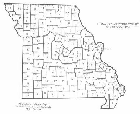
The area around St. Louis, Missouri, had the most tornadoes per unit area. This was not only because there were a lot of people in and around St. Louis, but there was a storm chaser and scientist named Ed Brooks who found and reported tornadoes that no one would have known about otherwise.
Looking at the map in Figure 1, there also seems to be more tornadoes on the west side of the state than the eastern side, although Kansas City (where the Missouri River reaches the west side of the state) probably accounts for some of the high numbers there.

Figure 1. Number of tornadoes in Missouri by County between 1916 and 1969. St. Louis is on the east side of the state, in the county that has 33 tornadoes. Kansas City is at the north end of the straight-north-south part of the state’s west border. Figure Courtesy of Grant. L. Darkow, University of Missouri-Columbia.
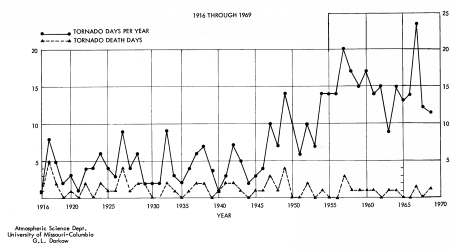
We also found out that the number of tornadoes went up with time, with a rapid increase in the 1950s. Some of this is related an increase in the number of people and newspapers with time.
Also, the Weather Service (then the Weather Bureau) started tornado forecasting in the early 1950s. So not only were people reminded to look for them, but weather forecasters would look for evidence of tornadoes to check to see how good their forecasts were. About the same time, the Weather Service started to publish summaries of tornadoes and other severe weather in Storm Data, making the information much easier to find.
Apparently my hard work between about 1965 and 1968 didn’t increase the number of tornadoes counted – aside from a big peak in 1967, the number of tornadoes was about the same as in the late 1950s.
Note that the tornado deaths stayed about the same in spite of the increase in population. If the number of tornadoes really had increased, a steady death rate might mean better tornado warnings. But we felt that the small change in the number of deaths meant that the number of destructive tornadoes hadn’t changed that much (and thus probably the total number didn’t either).

Figure 2. For the state of Missouri, tornadoes and tornado deaths by year. Note the big jump in the mid-1950s, which corresponds to when the Weather Service formally started recording storm occurrence in Storm Data. Figure courtesy of Grant L. Darkow. University of Missouri-Columbia.
Tornadoes occur with strong thunderstorms, which usually produce lots of rain. An easier question to answer is whether there are more heavy rainstorms.
Why is this? First, there are lots and lots of rain gauges. But they are not everywhere, so scientists lump together several gauges in an area. Obviously, the time changes will be more accurate if the area is large enough to have lots of rain gauges with records for a long time.
But the areas you look at should be small enough so that you can see how things vary from place to place. By very carefully combining rain gauge records and measuring how accurate the resulting trends are, Pavel Groisman and his colleagues at the National Climatic Data Center found out that they can detect an increase in very heavy rainfall in the east-central United States. In other places, the trend is too small to say for sure using their methods.
Since thunderstorms clouds are cumulonimbus clouds, you could count observations of cumulonimbus clouds to see whether there are more thunderstorms. (To see what a cumulonimbus cloud looks like, see the cloud chart.) Between the early 1950s and the early 1990s, when human observers were replaced by automated weather stations, there was a good continuous record of cloud-type observations by U.S. Weather Service human observers. (Now, students like you take observations for GLOBE-related projects like the CloudSat mission for “ground truth.”) During this time, the number of cumulonimbus cloud observations increased during the spring and fall, but the reports didn’t change much during the summer. The authors suggest that the spring and fall increase is related to more warm days as winter gets shorter.
So the small number of clues here suggests that there are more heavy rain events in some parts of the country, and there are more thunderstorms clouds – in the spring and fall. But we really can’t see whether there are more – or fewer – tornadoes.
And the much harder question is to answer is, “why?”
My sincere thanks to Grant Darkow for checking my facts and allowing me to reproduce his figures. And I wish to dedicate this blog to the people of a beautiful town I visited and enjoyed very much about 10 years ago – Greensburg, Kansas, which had a devastating tornado last week. Best wishes for a full recovery – and no tornadoes for another 100 years – at least.
