On 7 December, when I wrote the blog below, we were experiencing a warm wind called a “Chinook” here in Boulder, Colorado. I wanted to wait until after the surface temperature field campaign to post this. It seems appropriate to do so this morning (30 December), since we are again experiencing a Chinook, and this blog was designed to follow the second birding blog. Winds have gusted to over 100 kilometers per hour, and the temperature outside is 12 degrees Celsius – quite warm for an early morning in December! During a Chinook, the temperature warms rapidly. Chinooks are also called “snow eaters” because they can make winter snows disappear quickly. They can also make the temperature rise suddenly by tens of degrees.
In my last blog on birding, I took a picture of a blind on Saturday, 6 December (Figure 1). Early that morning, the temperature was cold (about -5 degrees Celsius) and the ground had about 12 centimeters of snow on the ground. The lakes near the blind were frozen when we arrived there around 9:30 a.m. local time. The temperature was probably still below freezing when I took the picture. The next morning, we woke up to 10 degree Celsius temperatures, and the 12 centimeters of snow we had in our yard had entirely disappeared. When we returned to the blind to record the how different things looked, it was 11:30 a.m. local time – about 26 hours later.
Figure 1. Picture of blind taken for last blog. Sawhill Ponds, Boulder, Colorado, 10:00 a.m. Local time. The snow was about 10 centimeters deep here; the lakes were frozen.
Figure 2. Picture of blind, roughly 26 hours later (11:30 Local Time, 7 December 2008). Note that not only has the snow disappeared, but the soil is dry in some places.
Basically the temperature didn’t fall much the night of 6 December – in fact it might have even warmed. This is because air is coming down from higher up in a Chinook. As air sinks in the atmosphere, it gets compressed (squashed) by having more air above it pressing down. This squashing warms the temperature – much as the temperature of the air in your bicycle tire warms when you pump (squeeze) more air into it. In sinking dry air, the temperature rises 10 degrees Celsius for each kilometer – quite a bit.
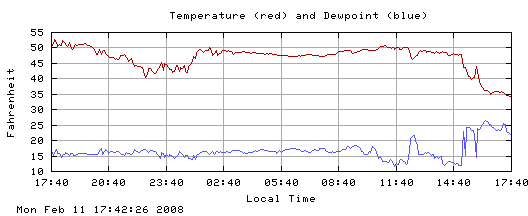
Figure 3 shows the temperature record for another Chinook (the instruments at NCAR Foothills Lab, which lies between where we live and Sawhill Ponds) weren’t working on 6-7 December, so I couldn’t get the data). The air is very dry during the Chinook. (The air is dry if the temperature is much higher than the dew point. Recall that fog or dew forms when the temperature and dew point are equal, so it makes sense that drier air has lower dew points). The dryness of the air is not surprising – the air is drier higher up. So the dryness is a sign that the air is coming from higher up.

Figure 3. Temperature and dew point from a Chinook on 11 February 2008, at roof level. From NCAR Foothills Laboratory in Boulder, Colorado. You can tell from the cooler temperatures starting around 15:00 local time that the Chinook ended about that time. From http://www.rap.ucar.edu/weather/.
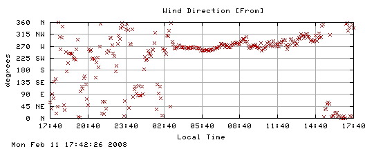
You notice how the temperature went up half way between 23:40 (11:40 p.m.) and 02:40 (2:40 a.m.) local time and then didn’t change much for the rest of the night like it normally does? Also the temperature wasn’t going up much the next morning. (Note: 50 degrees Fahrenheit is about 10 degrees Celsius). During this time the wind was out of the west – from the mountains, meaning sinking air (Figure 4). Also notice that the temperature cools off when the wind changes from west to north at around 15:00 local time (3:00 p.m.).

Figure 4. As in Figure 3, but for wind direction
The lack of a temperature change makes me think that the air in Boulder didn’t just simply slide down the mountain, but we were getting air from above the surface. Air high above the ground doesn’t cool or warm as much as air right next to the ground does.
So we have four clues that the air came from higher up during the Chinook. First, the temperature rose to abnormally high levels at the onset of the Chinook and rapidly cooled afterward. Second, the wind came from the mountains to the west. Third, the air was very dry. And finally, the temperature didn’t change during the day like it normally does. The last clue also suggests the air came from above the surface.
What do the clouds look like? In a Chinook, the wind blowing across the mountains flows in ripples much like the water flows over rocks in a stream. It’s harder to see air flow than to see the water flow. However, clouds occur when the air is at the top of ripples, if the air is moist enough. From the surface here in Boulder, we saw a long line of low clouds stretching along the mountains (one ripple), and higher cloud doing the same thing, but farther east (Figure 5).
Figure 5. Clouds associated with the Chinook at 14:50 local time, looking northwest. The mountains are to the west. The cumulus clouds near the horizon are just to the east of the mountains, which are not visible on this picture. The higher clouds (altocumulus) are part of a broad north-south band starting east of the mountains. The little tail in the middle is the leftovers from a contrail. Looking eastward, I could see that the altocumulus clouds stretched to the horizon.
You can probably see this more clearly from space. First, I show you the visible image (Figure 6). You can see some ripples over the mountains, a dark area stretching from Boulder (plus sign) to the south, and the altocumulus (or higher) clouds extending east-south east from the dark area.
Figure 6. GOES satellite visible image of clouds at 2132 UTC (1432 Local Standard Time). The plus sign snows where Boulder is. Note the north-south clouds along the Rockies in the middle of Colorado (like ripples in the water). Then there is a broad band of clouds stretching eastward to the east side of Colorado. This is the larger-scale view of the altocumulus in Figure 5. From http://www.rap.ucar.edu/weather/satellite/.
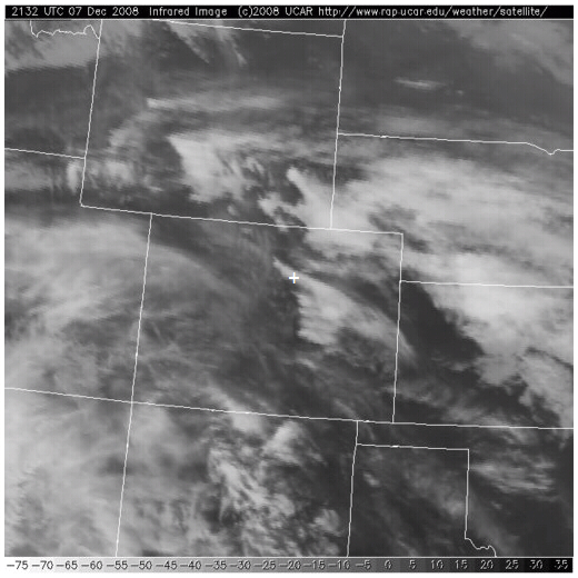
We can see the difference in the heights of the “ripples” and the broad area of altocumulus clouds by looking at the image showing the infrared signal (Figure 7), which is related to the temperature the satellite “sees” – either at the surface or at the top of the clouds. Since the temperature in the atmosphere drops with height at these heights, this temperature can be used to estimate cloud top height. The brighter areas indicate higher cloud tops, so the broad band of clouds to the east of Boulder appear to be higher than the ripples, which are hard to see.

Figure 7. GOES satellite infrared image in and around Colorado at 2132 UTC (1432 local time). The plus sign shows where Boulder is. The broad bands of clouds are showing up much more than the ripples. Since lighter colors indicate higher clouds, this tells us that the broad area of clouds to the east is higher than the ripples – just as in the picture I took in Boulder. (But I’m not sure we can see the ripple in my picture on the satellite). From http://www.rap.ucar.edu/weather/satellite/.
What was the result of the Chinook? We already pointed out the much warmer temperatures, the complete melting of our snow (12 cm in our yard originally), and the melting of ice on many of the lakes.
This also affected the ducks in the lakes near the blind.
On 6 December, when we went out to photograph the blind, we could find no ducks on the frozen ponds – only Canada geese waddling on the ice. Also, there were almost no birds at the feeders in our back yard. We were surprised, because we thought they would be hungry in the cold weather.
On 7 December, when we got up, the feeders were full of birds. So were the trees: chickadees, pine siskins, sparrows, finches, juncos, and collared doves, were eating continuously, even when squirrels and cats (and in one case a deer with antlers) came by. Today, when we went back to Walden Ponds (north of the blind), we saw many ducks on the one pond that had thawed out most completely. And the ducks and geese were eating. My guess is that they were making up for yesterday. But – there is a mystery. Where were the ducks during the cold weather? What do you think?
Do you have names for winds where you live? Winds – particularly those that bring different weather – have names around the world. In Africa, the hot dry winds that come south from the Sahara are called Harmattans. In southern Europe, cold winds that come out of the mountains are called Boras and warm winds that come out of the mountains are called Foehns in Germany. However, we also use the word “foehn” to describe warm dry winds from the mountains in the United States. In South Africa, the warm winds coming from the mountains are called “berg winds,” since “berg” means mountain in Afrikaans. There is no snow to melt, but the berg winds do raise the temperature in winter.
