This week we have a guest blogger, Jennifer Bourgeault. Jennifer, a member of the GLOBE Land Cover/Biology Team for 10 years, is the North Country Education Services (NCES) New Hampshire GLOBE Partnership coordinator and Master Trainer in the Land Cover/Biology protocols. She thinks everyone should know how to use the Modified UNESCO Classification (MUC) Field Guide to classify land cover and how to use Multispec to look at change over time.
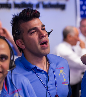
Unlike the Rover landing, no one from the National Aeronautics and Space Administration (NASA) Landsat Data Continuity Mission has appeared in the media write-ups with a Mohawk to encourage students around the world to think that science, technology, engineering and mathematics can be both cool and exciting.

Mars Science Laboratory (MSL) Systems Engineer Bobak Ferdowsi is seen reacting after the MSL rover Curiosity successfully landed on Mars, Sunday, Aug. 5, 2012 at the Jet Propulsion Laboratory in Pasadena, Calif. Photo Credit: (NASA/Bill Ingalls)
Despite the relatively quiet coverage, on 11 February 2013 at approximately 18 UTC (1 pm EST), many scientists watched the launch with nervousness and anticipation, including me. I had been counting down for days. My colleagues and friends were both tired of my daily countdown and upset when I missed a day. But many of them really didn’t know why I was so excited and what this launch means to GLOBE and to scientists who use remotely sensed data.
Fast fact: Once the satellite is fully tested, operational and in the hands of the United States Geological Survey (USGS), it will be known as Landsat 8.

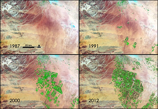
NASA Sees Fields of Green Spring up in Saudi Arabia. Credit: NASA/GSFC/Landsat
For 40 years, we have been able to access data showing us how the Earth has changed over time. We have been able to download these data for free for years. By using MultiSpec (a free digital image processing software), there were no constraints on how young or old users were, what country they were from, by whom and for how much they were funded, or not funded, or even what they were using these data for in their research. Scientists, students, and citizens of every country in the world could process these data, create images, and study the Earth and its changes over time with a computer, a tutorial and basic remote sensing knowledge. These data are at spatial, spectral and temporal (passes over a location every 16 days) resolutions that can be used to consistently monitor ecosystems and forest types, natural disaster impacts from floods, volcanoes, and fires, and urban development.
Fast fact: For GLOBE land cover mapping, we typically use 5 spectral bands – 3 visible light and 2 near-infrared – with 30 meter spatial resolution.
What if this launch did not go well? Landsat 5, with a projected lifespan of only three years, was recently decomissioned after 30 years of collecting data!

The decommissioned Landsat 5 gets a new title by setting a Guinness World Record as the “Longest Operating Earth Observation Satellite.” Credit: USGS
Landsat 6 never achieved orbit. Landsat 7 collects data, but it has large gaps in coverage for each scene. Would our data record of the Earth stop? No. There are other satellites and other ways to collect data – but not for free, and not with the breadth of Landsat. Landsat is a lot like GLOBE: accessible to everyone, everywhere, with a legacy of data and an amazing mechanism to continue on its mission, with no boundaries. And the possibilities are endless when GLOBE research is carried out by students using Landsat data.
On Monday, Feb 11th, if you weren’t cheering on the launch or weren’t thinking about its significance for GLOBE, don’t worry; I was doing enough of that for all of us.
“Landsat is the one monitoring system that for the last 40 years has provided every citizen of planet Earth the scale and the resolution to observe – for himself or herself – the changes and the ability of this planet to provide for each and every one of us those services that we require. I’m happy to say that thanks to that flawless launch today, the Landsat legacy will live on.” - Marcia McNutt, director of the USGS
Suggested activity: Did you watch the launch of Landsat, or have you been using Landsat to do GLOBE? Let us know about it either on Facebook or through the “Tell us about it” link on your profile page on the GLOBE website. You can also read more about Landsat by looking at the fact sheet. And finally, be sure to check out some of Jennifer’s favorite Landsat photos.
