
I was watching a baseball game at Coors Field in Denver, Colorado, USA, when a big fat raindrop fell on my lap. I looked up — and there were only small altocumulus clouds overhead.
Where did the drop come from? Not from the altocumulus clouds — they were too thin, and the raindrops were big, even if there were only a few, so I guessed they came from a cumulus-type cloud. No one was pouring a drink from the upper seats: the drop wasn’t sticky.
In this case, the explanation is probably simple. The raindrop took a long time to fall from its parent cloud. By the time the raindrop fell to the ground (or rather my lap), its parent cloud had either changed, or more likely moved out of sight.
Cumulus and cumulonimbus cloud bases over Colorado are often higher than usual. This is because the air is very dry. Dry air has to rise a long distance before it can form cloud. Why? Clouds like the one that produced the raindrops form when air rises and cools. As air cools, the relative humidity rises. Once the air is “saturated,” that is the relative humidity is 100 percent, tiny water drops start to form. If the air near the surface is moist, the air doesn’t have to rise very far. For example, over the tropical oceans, the base of cumulus clouds in fair weather is about 600 meters above the water. And, if the relative humidity at the ground is 100%, you can get fog — the cloud base is zero meters above the ground.
So, on dry days, we see cloud bases that are even 3000 meters above the surface.
Scientists have measured the fall speed of raindrops in the laboratory and using radars looking straight up. Larger raindrops fall at higher speeds. I will assume my raindrop fell toward the ground at 8 meters per second.
If the cloud base was at 3000 meters, it would take 3000 meters divided by 8 meters per second, or 375 seconds, for my raindrop to fall from the cloud to my lap. That’s over six minutes. During that six minutes, the cloud probably moved out of my sight. Coors field is surrounded by three tiers of seats and high walls; so my view of the cloud could be easily blocked. For example, if the wind at cloud level was 20 meters per second, the cloud would have moved 7.5 km away by the time the raindrop hit the surface. If the wind at cloud level was 40 meters per second, the cloud would have moved 15 kilometers away. So, the cloud could have easily moved behind the “nosebleed seats” (the highest seats).
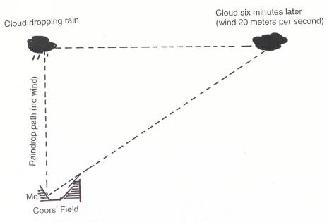
Illustration showing possible explanation for the rain with no cloud. Coors Field bleachers blocking my view. Not drawn to scale.
I assumed the raindrop would fall straight down from the cloud’s original position over my head. This would happen only if the wind was calm below cloud level. However, I don’t think it’s a bad guess, since the average wind between the cloud base and the ground could have been close to zero.
Just for fun — watch how the rain falls from distant clouds — sometimes it falls straight down (when the wind is the same through the rain and cloud), and sometimes it falls behind the cloud (when the wind “steering” the cloud is faster than the wind below cloud base), and sometimes it spreads out when it reaches the ground (when the air is also spreading out).
Thank you very much for your explanation. It\’s really interesting for me. I am a beginner in GLOBE programme. I am wondering whether there is any posibility to measure the base of cloud. I am trying to recognize them (just 10 types in Globe programme) and it would be useful to know how far they are from the ground to narrow clouds down to middle, low, high type. According to your explanation the position of the same type of clouds is different in various places in the world so I have to find out what the pattern is in my latitude (Poland).
How did you assume that the speed of your raindrop was 8 m per second?
How is the speed of hail.. does bigger hail fall at a faster speed?
Hi Jaga,
Thanks for the questions! You have given me an idea for my next blog. I’ll talk more about how you find the speed of drops — and also hailstones!
Clouds are really hard to recognize, because of course there are many more than ten kinds. To see more clouds on the GLOBE web site, you can go to the “Educators Corner” and click on the “Cloud Protocol — Online Teaching Module. Also, the “cloud quiz” will show you many types of clouds. All fit into the 10 types, but some fit better than others.
And don’t get discouraged if you don’t do very well on the cloud quiz the first time. I took the quiz with some students who were studying to be metoeorologists and we all did poorly. Why? Because some of the pictures weren’t very good. We removed the bad pictures from the quiz, but it might still be hard. For many reasons. First, it’s hard to identify clouds from pictures (even good ones). And seondly, as noted above — there are just so many kinds of clouds!
The cloud classification that GLOBE uses actually uses pretty well for Europe, since it was invented in England.
If you have questions about clouds — or have picture of a cloud you want me to identify — I would be glad to help.
Great post! I’ll be back to get useful information.Tks u!