2011 has been an interesting year in regards to rainfall for the GLOBE country of Thailand, as both the north and south portions of the country have seen significant flooding. Let’s take a look at Bangkok, the capital city of Thailand, which is located in the north, as well as Phuket, which is located in the south. Here’s a map of the country for those who aren’t familiar with Thailand, with the cities of interest indicated by the red dots:
First, we’ll begin by examining the major flooding that occurred in the southern portion of the country in early 2011.
In Phuket, the following chart from weather-and-climate.com shows the distribution of precipitation through an average year:
Looking at the chart, there are clearly two seasons in relation to precipitation: a dry season that runs roughly from November through April, and a wet season that runs from May through October. What was interesting about the flooding in the southern portion of Thailand in 2011 was that it occurred in March, which is during the dry season.
Other than looking at precipitation, one way to determine the difference between the wet and dry season is to look at air and water temperatures relative to each other. The dry season is characterized by cooler temperatures over the land, and warmer temperatures over the ocean. GLOBE schools in this region could verify this by examining both the Max/Min/Current Air Temperature protocol as well as finding a data source that provides sea surface temperatures from ships or buoys. Because of these temperature differences, a gradient forms, and the winds will blow from the Northeast, bringing cooler air in from China.
In early 2011, an unusual cold wave hit the region, and temperatures were below average for a few days. This caused the normal temperature gradient seen in the dry season to be even more pronounced. While this doesn’t sound like something that would cause major flooding, more convection formed due to the different amounts of heating and caused this devastating flooding.
The flooding that is currently occurring in Thailand, however, is due to different causes, and yet is just, if not more, devastating than the flooding in Phuket.
In Bangkok, the following chart from weather-and-climate.com shows the distribution of precipitation through an average year:
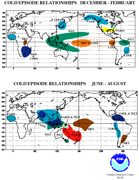
The current flooding in the northern portion of the country began in late July, which is during the monsoon season. As we mentioned when we looked at the Near East-North Africa Region’s State of the Climate for 2010, the monsoon is a circulation pattern that carries moist air from the Indian and Pacific Oceans into Asia. In addition to the monsoon, La Niña conditions increased the amount of rain that normally falls during the monsoon. The following image may look familiar, as it was included in the Latin America-Caribbean State of the Climate post from a few weeks ago:

You’ll notice that over Thailand, precipitation increases during a La Niña event. For the months of August, September, and October, Bangkok recorded nearly 950 mm of rainfall, when the normal is only approximately 750 mm. However, this anomalous precipitation was not the only cause of the flooding; large amounts of runoff from rain that fell even further north in Thailand reached Bangkok by October.
While the flooding is still occurring, it appears that the worst may be over, according to Bangkok officials. For more details on the extent of the flooding, please read this article from the Vancouver Sun.
If you’re a GLOBE school in Thailand, have you experienced any of this flooding? We would love to hear about your experience through a comment!
-jm


