This week we’ll continue our look at the climate summaries for each GLOBE region, with a focus on the Latin America-Caribbean region. Remember that these annual reports provide a summary of the global climatic conditions and are a great benchmark for monitoring climate. You can use this data in your own GLOBE climate research projects!
Regional reports provide a tremendous amount of information including temperature, precipitation, tropical cyclone activity, and notable events. Temperature and precipitation climate summaries are highlighted here; more information about the Latin America-Caribbean Region state of the climate is available from this website: http://www1.ncdc.noaa.gov/pub/data/cmb/bams-sotc/2010/bams-sotc-2010-chapter7-regional-climates-lo-rez.pdf
The Latin America-Caribbean region has many similarities to both the Asia-Pacific region and the Europe-Eurasia region . There are island countries, such as the Bahamas, countries that are landlocked, such as Paraguay, and countries that are highly mountainous, such as Chile, which is similar to the Asia-Pacific region. But Latin America-Caribbean is similar to Europe-Eurasia in that some of these countries are considered to reside in the mid-latitudes, which experience a wide variety of weather.
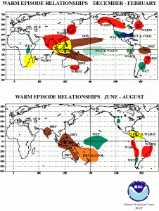
An important factor to make note of is that the beginning of 2010 was the end of El Niño phase in the equatorial Pacific and the development of La Niña in mid-2010. Each have a different impact on weather and climate in this region which can make a summary of the climate rather complicated. During El Niño (“warm episode”) the impacts in December-February and June-August are shown in the figure below from the NOAA Climate Prediction Center.
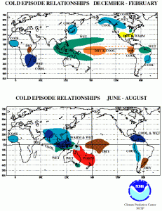
During La Niña (“cold episode”) the impacts are quite different.
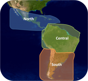
Latin America-Caribbean is an interesting region to examine, because it spans two hemispheres! So while one hemisphere is experiencing summer, the other is experiencing winter. We’ll take a look at the Latin America-Caribbean region in three regions: north, central, and south.
Temperature
The north sector includes the GLOBE countries of: Bahamas, Costa Rica, Dominican Republic, El Salvador, Guatemala, Honduras, Mexico, and Panama.
In the northern most part of the sector, Mexico and the Caribbean side of Central America recorded slightly warmer than normal temperatures. On the Pacific side of Central America, however, temperatures were below average, possibly associated with La Niña.
The central sector includes the GLOBE countries of: Bolivia, Colombia, Ecuador, Peru, Suriname, and Trinidad and Tobago.
In Colombia and Ecuador especially, temperatures were about +1.0 to +1.5 degrees Celsius above the 1971-2000 average. The other countries in this sector did not experience such strong signals. Suriname was the opposite of Columbia and Ecuador, where temperatures that were about -1.0 to -1.5 degrees Celsius below average were observed.
The south sector includes the GLOBE countries of: Argentina, Chile, Paraguay, and Uruguay.
This sector saw slightly below average temperatures for 2010. Paraguay experienced unusually low temperatures and snowfall from May through August. Some overnight temperatures were as much as 10 degrees Celsius below the average, causing many regions to declare states of emergencies!
Precipitation
In the north sector, 2010 was the second wettest year in Mexico since 1941. Record high precipitation was recorded for the months of February and July. These heavy rains caused mudslides, yet also filled dams that had been depleted due to many years of drought. Tropical cyclone activity and heavy rain associated with them contributed to the large rainfall in Mexico. In 2010, there were 13 named storms in the Caribbean, with seven hurricanes and three major hurricanes. This does not include the tropical depressions, which are not named but can still bring large amounts of rain.
In the central sector, the influence of El Niño and La Niña was apparent. While temperatures in Colombia and Ecuador were above average, so was their precipitation. The other countries observed below average rainfall, with values of 20-40% below average. In January, strong hail and precipitation caused flooding along the Vilnacota River, interrupting railway service and forcing evacuations.
In the south sector, recall temperatures were only slightly below average however, precipitation was significantly below average. Rainfall deficits were about 20-80% of normal. Even with the deficits, the sector experienced extreme precipitation events, which included flooding and snowfall that lead to destruction of bridges and other man-made structures.
Does your record of GLOBE data for the past year show any similarities to the summary provided here? Have you had any significant events have you in your local area? Please share them with us through the comment option below!
Join us next week as we continue on this journey through the GLOBE regions with a look at our fifth region: North America.
-jm


