This week we’ll continue our look at the climate summaries for each GLOBE region, with a focus on the North America region. These annual reports provide a summary of the global climatic conditions and are a great benchmark for monitoring climate.
Regional reports provide a tremendous amount of information. The temperature and precipitation climate summaries are highlighted here, but if you are interested, more information about the North America Region state of the climate is available from this website: http://www1.ncdc.noaa.gov/pub/data/cmb/bams-sotc/2010/bams-sotc-2010-chapter7-regional-climates-lo-rez.pdf
The GLOBE North America region, while only comprised of two countries, includes widely different geographic features. Both countries feature beaches on both coasts, and mountain ranges. The extreme southern tip of the United States has an equatorial climate, while the extreme northern portion of Canada has a polar climate. Let’s examine the state of the climate for both countries for 2010.
Temperature
In Canada, 2010 was the warmest year since nation-wide records began in 1948. Temperatures were about 3.1 degrees Celsius above the 1961-1990 average.
The United States did not observe departures from normal as extreme as Canada, and 2010 ranked as the 23rd warmest year since nation-wide records began in 1895. While most of the country observed near- or above-normal temperatures, the Southeastern United States, which includes Florida, Georgia, Alabama, and Mississippi, observed temperatures that were below or much below normal.
Precipitation
2010 recorded an above average year for precipitation in Canada. There were quite a few events that contributed to this. In September, Hurricane Igor made landfall in Newfoundland, Canada, an area that does not experience many hurricanes. The hurricane caused flooding and isolated many communities. Further west, the Canadian Prairies observed a shift in precipitation patterns. The early part of the year brought drought concerns, yet by April, enough rain had fallen to change those concerns of drought to concerns of flooding.
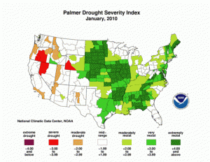
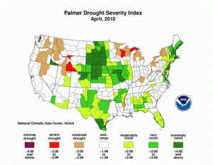
The United States also saw above average precipitation, with 2010 ranking as the 35th wettest year since nation-wide records began in 1895. This was especially true in the western half of the country. The months of January through March was the 15th wettest, mostly due to El Niño. The following two images from NOAA show the Palmer Drought Severity Index (PDSI) for January of 2010 and again in April 2010. The PDSI is an index that uses both temperature and precipitation information in a formula to calculate dryness. Here you will see the relief due to the rains in the western half of the country.
Like Canada, there were concerns of drought, mostly located in the western Great Lakes, south through the Ohio River Valley and eastward to the Mid-Atlantic states. However, by November, enough precipitation had fallen to relieve some of the drought concerns, especially in the Ohio River Valley.
If you’re interested in learning more about the State of the Climate for the GLOBE North America region, there is much more detail in the actual report summary: http://www1.ncdc.noaa.gov/pub/data/cmb/bams-sotc/climate-assessment-2010-lo-rez.pdf.
If you are a GLOBE school in the United States or Canada, how did your weather and climate compare to this summary? Do you have examples of extreme or notable events to share with us? Do you have GLOBE data for your sites that support this summary? Let us know!
Next week, we’ll finish our journey through the GLOBE regions with a look at our sixth region: Near East-North Africa.
-jm


