Fire Weather

The two pictures show two forest fires burning to the southeast of where we were hiking on 16 July. We were north of the Charles M. Russell Wildlife Refuge, in northeastern Montana. The wind was strong — 32-48 kilometers per hour — and blowing from the west-northwest.

It is likely that lightning from thunderstorms on the evening of 14 July started both fires — and four more we saw on the 16th. 15 July was cool with light winds, and the ground was wet from the rain, so the fires grew slowly. But on 16 July, strong winds, hot temperatures, and low relative humidity made the fires grow much faster. We had been warned — there was a “Red Flag Warning” for high fire danger — because of an extended drought, hot temperatures, strong winds, and dry vegetation.

Forest fires to the southeast about noon on 16 July 2006, off Dry Fork Road, north of the Charles M. Russell Wildlife Refuge

At same location about one hour later.  Notice that the smoke reaches farther up off the ground 
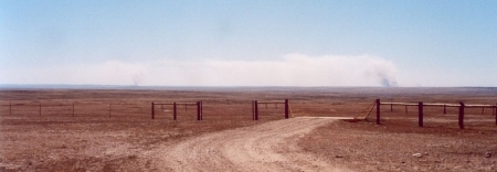
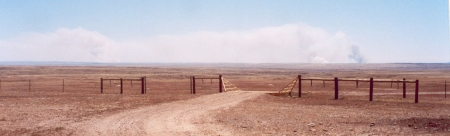
Figure 1. Top: Forest fires to the southeast about noon on 16 July 2006, off Dry Fork Road, north of the Charles M. Russell Wildlife Refuge. Bottom: At same location about one hour later. Notice that the smoke reaches farther up off the ground.

As we watched, the plumes of smoke sometimes rose almost vertically, suggesting rapid upward movement. Were we looking at the fires from the side — so that the wind was traveling exactly from right to left — we could have estimated the upward wind speed from the tilt of the smoke plumes. For example, a 1:1 tilt (45 degrees) would mean the hot smoke was rising at the same speed as the wind was carrying it to the left — 32-48 kilometers per hour.

From looking at the position of the fire from different locations as we drove toward Malta, Montana, we guessed that the fire to the right was about 25 kilometers to the southeast of where the photographs were taken.

The next day, we wanted to come back to roughly the same spot, but the wind had changed to southeast, carrying the smoke directly toward us. We could barely see distant hills, and it was hard to breathe. The wind direction change was good for the firefighters, however, since the fire was being blown back over fuel (e.g., trees or grass plus fallen leaves, etc.) that had already burned.

Signs of Dry Fork Road off U.S. 191, showing poor visibility on the 17th of July 2006 
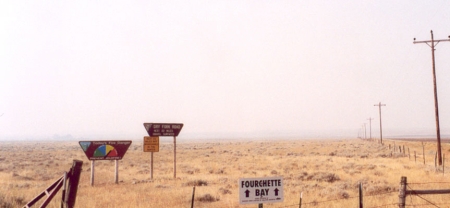
Figure 2. Signs of Dry Fork Road off U.S. 191, showing poor visibility on the 17th of July 2006.

See the January 2004 Chief Scientist’s message and the Fire Fuel Protocol if you want to find out more about wildfires.

Posted in Atmosphere | 10 Comments

Global Warming?

The newspapers and television are full of stories about “global warming,” so I thought I’d address this term briefly today — and get back to more of the science later.

What does “global warming” mean? “Global warming” is really an unfortunate choice of words. What climate scientists refer to when they talk about temperature changes over decades and centuries is a global average — over the oceans as well as land. And normally, they refer to the air temperature about 1.5 m above the surface, the “surface air temperature.”

So, if someone says that Earth’s temperature has warmed about 1 degree C over the last century, it does not mean that the surface air temperature everywhere has warmed by that amount. In fact, some places — for example, parts of the southeastern United States actually got a little cooler!

A few years ago, as part of a workshop, we asked teachers to plot graphs of average temperature as a function of year for the Weather Service station nearest their schools. All of these teachers lived in the state of Colorado. No one could really see any change from the graphs. Looking at maps of the temperature trends in the “lower 48″ United States, we can see why — Colorado is roughly at the boundary between where there is warming (the northwest U.S.) and the neutral-to cooling southeast U.S.

Can you find out how the temperature has been changing where you live? Have other things (rainfall, amount of snow, number of big snowstorms, seasons, spring thaw, first freeze, last freeze) changed where you live? This would be a good thing for students to ask their grandparents or other senior citizens. Even better — find out what students are observing in other parts of the world.

Posted in Atmosphere, Climate Change, Earth System Science | 1 Comment

GLOBE at Night — can you see the stars?

When I was in Washington, D.C., a few weeks ago, the TV weather forecaster said “It will be partly cloudy this afternoon with sunny skies tonight.” After a few seconds, I realized what he said and laughed.

But, even without sunlight, the light in cities is bright enough to read a book by.

GLOBE at Night (http://www.globe.gov/GaN/analyze.html) was a web-based field campaign held a few weeks ago to let people report what the night sky looked like where they lived. They looked at a familiar constellation, Orion. The more stars that they could see, the “better” the net sky for observing stars. Some people probably drove or walked to their favorite observing spot. When I was a child, we had a favorite place to go just outside of town to view comets or satellites.

Light pollution is really what makes it hard to see the night sky. I thought when I was younger that the other types of pollution — especialy dust, would be very important. Certainly, during the daytime, sunlight scattering off dust makes it difficult to see distant mountains or hills. But at night, with no lights, the stars are surprisingly easy to see, even under dusty conditions.

I learned this while working in Dakar, Senegal, the Summer of 1974. We lived near Dakar-Yoff airport, because we were flying research aircraft over the Atlantic to study the weather. During the day, the sky on fair-weather days was quite hazy from all the dust in the air. This dust came from the dry ground nearby (it was quite dry) and from the Sahara desert just to the north. At night, though, the stars shone brilliantly. If it wasn’t raining or cloudy, we could see the Milky Way Galaxy.

I hope that you have a good place to go to — once in a while — to just look up at the night sky and see the stars.

Posted in Atmosphere, Backyard Science, Field Campaigns | 1 Comment

Looking at the Seasons from Space

By the calendar, Spring in the Northern Hemisphere began on 21 March. At our house, we heard the first robins singing on 27 February. Snow is still possible in Colorado for a few more months, but the air temperatures are, on average, getting warmer. The trees are leafing out.

On the GLOBE web site, you can see some reports of budburst. These reports should creep northward in the Spring in the Northern Hemisphere. Similarly, you might also look for how far north the Rubythroated Hummingbirds have gone (also see www.rubythroat.org). Most importantly, look for other signs of Spring’s arrival (or Autumn’s arrival) at your home or school. From my time working in the tropics, the biggest changes seem to have to do with rainfall.

Want to see the seasons from space? A recent issue of EOS, which is published by the American Geophysical Union, points to a web site — bluemarble.nasa.gov, where you can do just that.

I found it most interesting to compare the winter image to the summer image. Looking at where I live, in the west-central United States, the ground appears brownish when there is no snow. This fits with what I saw outside. The grasses were dormant, and the trees had lost their leaves. In the summer, the same area is green, because the satellite, like us, “sees” the leafed-out trees and green grasses. How do things change where you live? How does it compare to what the satellite image shows?

These images are from the Terra MODIS (MODerate-resolution Imaging Spectroradiometer), and they have a resolution of 500 meters. This is big enough to see a big lake, but not a football field. Before the images could be produced, the effects of clouds, dust, haze, and even the air between the satellite and the surface had to be removed.

Happy Earth Day!

Posted in Climate, Land Cover, Seasons and Biomes | 2 Comments

What is Science — Part 4

You don’t have to find dinosaur tracks to practice a little science.  Just look outside and see if you can explain what you are seeing.  Don’t make it too hard.  And don’t worry about observing something for the first time.  If it is your first time, you can solve your own mystery.  Here’s an example.

My husband and I take a walk around sunrise every day.  There are mountains to the west of where we live.

One morning a few months ago, we noticed five crows flying from the foothills toward the Sun.

Then we noticed that it happened almost every day.

Our question:  “Why do crows fly from the west toward the Sun every morning?”

In this case, we talked to a person who knew a lot about birds.  He said that crows roost in the mountains at night, and then fly east into the city during the day.

Do you have any ideas about why the crows would fly into the city during the day?

We noticed this behavior during the winter.   We will be watching to see if the crows do this during the summer as well.

Posted in General Science | Leave a comment