Students, teachers and scientists explore Mt. Kilimanjaro through GLOBE protocols and blogs

Beginning on 23 September, seven GLOBE students, six teachers, five scientists and one GLOBE alum will commence on a journey through the biomes of Mt. Kilimanjaro in Tanzania, Africa. Known as “The Xpedition,” the 2012 trek marks the fifth year of this exciting journey. This year will be bigger than ever as a documentary film crew will join them. In addition, we will be sharing images via social media and posting blogs from the mountain.

Mt. Kilimanjaro

Mt. Kilimanjaro

Background: The Xpedition began in 2008 when a team of 29 climbed Mt. Kilimanjaro to raise awareness of changes in global climates due to global warming. Deeper than that, the team wanted to look at possible solutions to problem.  While on the journey, data from various GLOBE protocols were collected. In 2012,  the plan is the same: collect data through the distinct biomes of Mt. Kilimanjaro through the GLOBE Seasons and Biomes Project. 

Bloggers from the mountain will be Bob Bolton, a scientist from The University of Alaska; Maddy, a student from Boulder, Colorado; and John Wood, a teacher at Talbert Middle School in Huntington Beach, California.  Each blogger will write posts centered on a specific question. Each question is different and focuses on everything from personal goals and expectations to scientific findings during the journey.  This will be interesting and informative and you are encouraged to join the conversation.  The first blog will be posted on Saturday, 22 September. Daily posts will continue through 2 October.

Meet the bloggers:

Bob Bolton was born in Idaho and raised in Wyoming.  He moved to Alaska with his family during high school. He received his Bachelor’s degree in Geology (California Lutheran University) in 1992, his Master’s in Geologic Engineering and PhD in Hydrologic Engineering, both from University of Alaska Fairbanks. Following a post-doc in Germany, he returned to the University of Alaska Fairbanks where he is currently a research assistant professor.


Bob Bolton

Bob Bolton

John Wood was born and raised in Southern California where he earned a bachelor’s degree in biology from Chapman University in 1977 and his masters in education from California State University at Dominguez Hills in 1995. His love of science took him to Scripps Institution of oceanography and research in Alaska, after which he spent nine years with the United States Antarctic Program as the laboratory facilities manager and research diving coordinator. Entering his 23rd year of teaching middle school science, he is currently at Talbert Middle School where he also coordinates their science fair program and helps coach the track team. He is a PolarTREC teacher of 3 expeditions and a PolarEducator with the Polar Educators International (PEI). His support comes from his wife Mary and his two daughters, Natalie and Lauren.


John Wood

John Wood

Maddy was born and raised in Boulder, Colorado and believes she’s been spoiled by the Rocky Mountains since she was a child. At age 15, her passion for travel took her to Sardinia, Italy where she participated as a rotary exchange student for her sophomore year of high school. She also visited Barcelona and Paris while abroad. Somewhere along the way she realized her favorite thing to be is abroad. Currently a junior at Boulder High School, she is working hard to graduate a year early so she can and study abroad in South America during a gap year. She spends a lot of time working as a swim teacher and manager at the Elks Swimming Pool in Boulder. She also volunteers regularly at soup kitchens and lives with her mom, dad and dog. Her brother is in college at the University of Colorado.

Maddy

Maddy

Be sure to join the team as it travels through the distinct biomes of Mt. Kilimanjaro.

Posted in Earth System Science, GLOBE Protocols, Seasons and Biomes | 7 Comments

Full Circle Superior Part III: Lake Levels and Global Climate

In 2010 Mike Link and Kate Crowley chose to walk around the largest fresh water lake in the world – Lake Superior which has shoreline in both Canada and the United States. This 1555 mile/145 day walk was the first ever by a couple and the first to attempt to stay on the shoreline. Because Mike and Kate are educators in their sixties they wanted to deliver important information about the lake to inspire others to care for it. As a researcher and college professor Mike wanted the adventure to have information for his courses and for research institutions around the lake.  This is Part III in the Full Circle Superior series.  For more information, read Part I and Part II.

Traveling around the lake was easier for us in 2010 than it might have been in other years. We faced a minimum of bad weather days, the insects were never maddening, and we had the knowledge that if we could get to the shore we could legally walk to the “normal high water” line and not be trespassing. This becomes more difficult when the normal high water line is half way up a cliff, but for most of Wisconsin, Michigan and up to Montreal Harbor in Canada, this fact made life much easier for us.

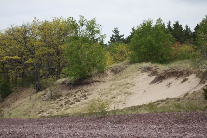
Dunes at Keweenaw

Dunes at Keweenaw

The reason that we could walk to the normal high water line was also the bane of many of the Canadian land owners: Lake Superior water level was down. Now, their docks were so far from the water that you could walk to the end of some docks and jump onto bare, dry rock. This was especially apparent to us on the Goulais Peninsula where there were break waters, docks, boat launches, and boat houses many meters from the water’s edge. As a result of this condition, and the fact that this has been a multi-year issue, the shoreline is being altered in ways that were not allowed in the past. The Ontario Ministry of Natural Resources has allowed some cabin owners to create channels to get their boats in and out.

In 2007, Seagrant published a newsletter that put a lot of perspective on the lake levels

“Since 1998, Lake Superior has slipped to the shallower side of average. This year the lake could sink to a new low. Experts point to two main reasons for this:

• Less precipitation
• More evaporation

Each year, about 2.5 feet (77 cm) of water hits Lake Superior directly as rain or snow. Two more feet flow in through streams and ground water, which reflect precipitation that falls on land within the watershed. This year (2010), precipitation has been short by about 6 inches (15 cm) across the Lake Superior Basin.

Less water in, more water out: Last winter’s sparse ice cover allowed more water to evaporate. Contrary to what one might guess, Lake Superior evaporates fastest from October to February when dry cold air from Canada moves over the warmer surface of the lake soaking up water like a sponge. The ice works like a lid on the big Superior jar and when it is left open the liquid meets the air and the air moves it out of the basin. When the lake looks like it is boiling in the winter, it is actually the water changing to vapor. This is normal up to a point.

For at least the last 150 years, Lake Superior has lost and gained massive amounts of water (on the order of 20 cubic miles) while maintaining a remarkably even water level, varying only about four feet (1.2 m).”

Since 2007 the conditions have not changed appreciably – the Army Corp of engineers in 2011 said the lake was 9 inches below 2010 levels. The ice cover on the lake in the winter has fallen far beneath the normal averages leading to more evaporation. This has had an impact on the south shore where “lake effect” snows are counted on for their winter economy. As the Sea Grant article shows, there is not much water moving into the lake. It has a small watershed for its size.

Globe media in Canada caught the significance of the 2007 low water point when it published an article by John Flesher who wrote, “Preliminary data show Superior’s average water level in September dipped four centimeters beneath the previous low for that month reached in 1926.”

Cynthia Sellinger, deputy director of NOAA’s Great Lakes Environmental Research Laboratory, said, “It is the first time in 81 years that the biggest and deepest of the lakes has reached a new monthly low.”
Along the way we found people who would say, ‘the lake always fluctuates, it will come back,’ but in fact, Flesher notes that the “lake has plummeted over the past year and has dipped beneath its long-term average level for a decade – the longest such period in its known history.”

We were not in a position to measure the lake, but we were in a position to observe what the lake looked like and in some places this was quite disturbing. In the next part in this series, we will discuss the effects on different industries due to a changing Lake Superior.

Posted in Climate, Climate Change, Earth System Science | Leave a comment

Salute to teachers

This week, we are taking a slightly different approach to our blog. At the highest level, our blog usually centers on science and education themes. This week, however, we are taking a step back to focus on the people who are on the front lines of teaching science and education … our teachers.

If you have ever been inspired by a great teacher––an educator who had such a profound impact on you life by taking an interest in you, sparking your curiosity in a particular subject or even by encouraging you to do your best, you will undoubtedly think of that teacher (or teachers) and recall the moments or events that ignited your passion the most.  Moreover, there is a strong chance that it was a teacher who inspired you to become a scientist … and for many of you, you are now not only scientists, but teachers as well.

The role of the teacher is mission critical and perhaps more important today than at any time before. This is especially true as it relates to fostering the next generation of scientists. Last fall, Microsoft Corp. released a study that suggests teachers are the key to getting students interested in STEM. More than half of the STEM college students surveyed (57 percent) said that before going to college it was a teacher or class that got them interested in STEM. It found that 78 percent of STEM college students decided to study STEM in high school or earlier; 21 percent decided in middle school or earlier.

STEM education is a pressing topic with big implications in the U.S.: currently the number of college students earning degrees in STEM fields is far short of demand for graduates with these skills. So how do we get students interested in STEM? It starts with teachers. It starts with you. Of course there are social and policy implications to all of this, but that is for another post on another blog at a different time.

We believe it is important to acknowledge the people who inspire us, nurture our curiosities and captivate our minds … for all of you who work tirelessly to close the gap and engage students in the study and discovery of Earth system science, the GLOBE Program would like to thank you. We value your efforts and we recognize the impact you have on the lives of the students you teach every day.

With the back to school season in full swing (especially in the Northern Hemisphere), we would like to commence the school year by showing our appreciation with a Salute to Teachers video. We encourage you to watch it and share the link with your friends, family, school administrators and, of course, all of the educators you know and appreciate so much.

Together we can inspire students to do more than read about science, but do science.

-Ron Zwerin

Posted in General Science | 3 Comments

Full Circle Superior Part II: Studying Streams

This is the second in a series about the science of Full Circle Superior; a walk around the world’s largest freshwater lake.  You can read the first blog post here. My wife, Kate Crowley, and I determined that we would be the first couple to walk around this lake, trying to stay as close to the shore as possible.  It was a commitment for two people in their sixties who wanted to leave a legacy for all grandchildren and to inspire people to be more conscious of the importance and threats to fresh water on our planet.  Lake Superior holds 1/10th of all the fresh water on the surface of the planet.  It took 145 days and 1555 miles to complete this journey.

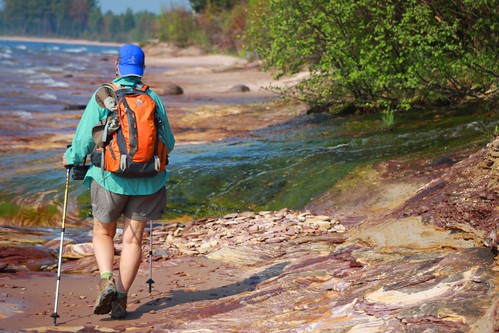
Walking Along Lake Superior

Walking Along Lake Superior

Studying the streams:

One of the goals of our trip was to understand more about streams connecting to Lake Superior.  Our primary concern for streams had been how to get across them.  Before we started the walk we tried to get some preliminary data to help us with logistics and one of those factors was how many streams we would cross.  In our quest to determine that number, we began to realize how little is actually known about this massive water body that shares shoreline with two countries.  The first estimate from a research facility was over 7000 streams.  This was an amazing and overwhelming number, but soon someone sent a note saying – you will have to cross 350 rivers.  This contrasting data will drive an expedition planner and a scientist crazy!.  We went back to the original source and they recalculated saying there were actually 1754 streams and the rest were interfluvials.  This term is actually an error since an interfluvial is the land between streams; the term they meant was seeps and springs – interflows.  Our hike encountered all 1754 streams and we crossed in many different ways.

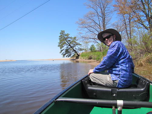
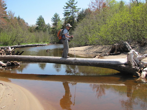
We waded many of the streams, but decided that waist deep was our limit.  Sometimes we were able to stop our trek on one side one day and begin the next day on the other side. We also canoed across two in Michigan and two dozen in Ontario, walked out to bridges on many, and crossed on numerous logs or rocks! Some stretches of shoreline had more river crossing than others, with the Amnicon to Brule River section of the Wisconsin shore and the Porcupine Mountains to Ontonagon in Michigan being the most concentrated stretches; each with 18 streams in a single day of walking.

Canoeing Across a Stream

Canoeing Across a Stream

Using a Log to Cross a Stream

Using a Log to Cross a Stream

The Need for Research:

We had not thought about the fact that these streams, during low water stages, can become isolated from the lake by sandbars. As more uses are found for Lake Superior water and as potential diversion and climate change combine, it is possible that the streams might stop connecting with the lake altogether during their normal low water time and the nutrients from the stream and fry from the spawning game fish could become cut off.   The spawning fish come in during high water, but if the spawn cannot return to the big lake, we will see our fisheries dramatically hurt.

We did our best to provide some meaningful information on streams connecting to Lake Superior, by measuring the width and depth of those we crossed; their GPS position, the time of day and date. These can then be matched with lake levels by research scientists and then projections can be made about low water threats.  To this we added photographs of the stream mouths to provide a visual reference point and a comparison for future observers.  This is something students can do on their river mouths.  Photo records of the stream flow with dates and GPS points is good baseline data and can be combined with weather and climate data.

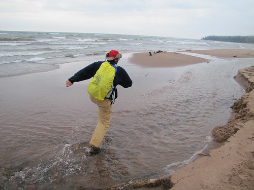
Running Across a Stream

Running Across a Stream

Have you studied a stream in your area using GPS, photography, or GLOBE hydrology protocols?  We would love to hear about your experiences!  Either add a comment or send us an email at science@globe.gov.


Posted in General Science | Leave a comment

Record sea ice minimums and snowier winters – what’s the connection?

As the northern hemisphere prepares to enter autumn on 22 September, scientists have been looking to the Arctic to gain clues as to what type of winter may be in store.  The winters of 2009-2010 and 2010-2011 produced the second and third largest snow cover levels on record.  Two years prior, in 2007, Arctic sea ice set a new record low in areal extent.

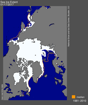
Map of sea ice extent on 21 August 2012

Map of sea ice extent on 21 August 2012 as compared to the 1979-2000 median; Credit: NSIDC

The Georgia Institute of Technology looked into the connection between Arctic sea ice extent and Northern Hemisphere snow cover.  What they found may be critical to seasonal snow forecasts and temperature anomalies across North America and Europe: the lower the sea ice extent, the snowier the winters can be.

Why does this happen?  Scientists believe that the enhanced melting of sea ice causes changes in the atmospheric circulation, increases the amplitude of the jet stream and increases the amount of moisture in the atmosphere.   Let’s take a closer look at these three impacts.

  1. Changes in the atmospheric circulation.  Because of melting sea ice, the westerly winds are able to decrease.  This sets up a “blocking pattern”, which is the positioning of high and low pressure systems, so that cold air masses can move easily from high latitudes to middle and lower latitudes in Europe and North America.
  2. Increasing the jet stream amplitude.  The jet stream is a rapidly moving zone of winds high in the atmosphere.  This stream is formed by the contrasting warm temperatures to the south and cold temperatures to the north.  The amplitude of the jet stream refers to how far north and south it reaches.  So a high amplitude jet stream means there is more than 1610 km between the bottom of the trough to the peak of the next ridge.
  3.  

    Image of a high amplitude jet stream

    Image of a high amplitude jet stream; Credit: weather.thefuntimesguide.com

  4. Increased atmospheric moisture.  It is easier, energy wise, for water to change state from a liquid to vapor than from a solid to a vapor.  Therefore, with more water existing as liquid than ice, evaporation occurs easier than vaporization would.  This increases the moisture in the atmosphere in the form of water vapor.

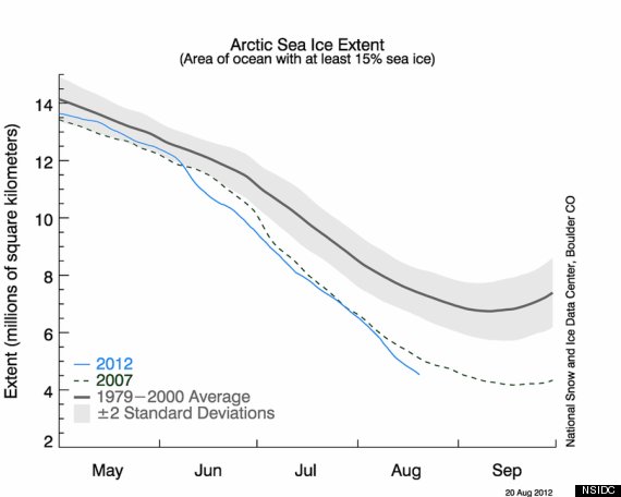
So if there is colder weather and more moisture available, then the conditions become more favorable for more frequent snow events.  This report is also timely, because the National Snow and Ice Data Center (NSIDC) is reporting that Arctic sea ice is forecasted to set another record low soon – as early as next week.  The difference about this year’s minimum, compared to the low in 2007, is that it is expected to happen very early in the season.  Typically the lowest Arctic ice extent is measured in late September, right before the equinox when the Arctic begins to enter a sunless winter.  This year’s trend is on track to break the record low and then still have even more time for potential ice melt through the end of the northern hemisphere summer.  Only time will tell how low the sea ice extent will go.


Arctic sea ice extent, 2012 versus 2007 record levels versus the 1979-2000 average.
Arctic sea ice extent, 2012 versus 2007 record levels versus the 1979-2000 average; Credit: NSIDC

This report is timely for many reasons.  One, as stated above, is that the northern hemisphere is beginning its transition to the autumn and winter seasons.  Second, September brings another occurrence of the Great Global Investigation of Climate, where schools are encouraged to collect temperature and precipitation data.  As a GLOBE school, you can be a part of this research – collect your school’s data, obtain records from the NSIDC and compare the two to see if there is a relationship between Arctic sea ice extent and the winter weather in your community.


-Jessica Mackaro

Posted in Atmosphere, Climate, Climate Change, Earth System Science | 2 Comments